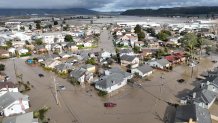
A levee break on a storm-swollen river in California's central coast has quadrupled in size, complicating repair efforts Monday and spilling floodwaters into farmland and agricultural communities — even as yet another storm fueled by an atmospheric river took aim at the already saturated state.
The Pajaro River's levee rupture grew to at least 400 feet since it failed late Friday, officials said. More than 8,500 people were forced to evacuate, and around 50 people had to be rescued as the water rose.
Built in the late 1940s to provide flood protection, the levee has been a known risk for decades with several breaches in the 1990s. Emergency repairs to a section of the berm were undertaken in January. A $400 million rebuild is set to begin in 2025.
Get top local stories in Southern California delivered to you every morning. >Sign up for NBC LA's News Headlines newsletter.
The river separates Santa Cruz and Monterey counties, about 70 miles (110 kilometers) south of San Francisco.
Monterey County officials also warned that the Salinas River could cause significant flooding of roadways and agricultural land, cutting off the Monterey Peninsula from the rest of the county. The city of Monterey and other communities are located on the peninsula.
Forecasters warned of more flooding, wind damage and potential power outages from a new atmospheric river that was expected to arrive Monday night in northern and central parts of the state and move south over several days.
The massive plume of Pacific Ocean moisture stretched all the way to near Hawaii.
“Avoid unnecessary travel and complete all preparations as soon as possible,” the San Francisco Bay Area weather office said.
California has already been battered by 10 atmospheric rivers this winter, most recently by a system that hit last week, as well as storms fueled by arctic air that reached blizzard status.
Gov. Gavin Newsom on Sunday declared a state of emergency in six more counties after earlier making declarations for 34 counties.
Last week’s atmospheric river carried warm subtropical moisture that caused melting at lower elevations of California's Sierra Nevada snowpack, adding to runoff that has swelled rivers and streams.
But the snowpack is so deep and cold that it mostly absorbed the rain, resulting in an even greater snowpack in the southern and central Sierra, said Daniel Swain, a climate scientist at the University of California, Los Angeles.
California Department of Water Resources online data showed Monday that the water content of the Sierra snowpack was 207% of the April 1 average, when it is normally at its peak. In the southern Sierra it was 248% of the average. The incoming atmospheric river-fueled storm won't be as warm as the previous one because it has incorporated cold air on the back end, Swain said.
Even though it won't be an extreme atmospheric river, its rain will fall on soils that are supersaturated, he said.
“This is why I'm more concerned about this one than the previous one,” he said.
In Southern California, rain is expected for most of Tuesday before tapering off Wednesday.
NBCLA's Jonathan Lloyd contributed to this report.

