What to Know
- The 1938 LA River flood was triggered by days of rainfall that far exceeded anything Los Angeles saw during February's storms.
- Part of Universal City's Lankershim Bridge crumbled in a collapse that added to what would become a staggering death toll.
- The devastating floods led to changes that altered Los Angeles' landscape.
In March 1938, two storm systems that lashed Southern California with record breaking rain triggered one of the worst floods in the region's history and pushed forward significant changes to the city's landscape.
The flood of March 1938 inundated parts of Los Angeles, Orange and Riverside counties with water due to storms that pounded the area from Sunday Feb. 27 to Friday March 4. The rainfall totals far exceeded those of recent storms that drenched Southern California with days of rain
To help put the storms in context, the Feb. 24, 2023 total of 2.29 inches marked the wettest day in roughly 20 years in Los Angeles. But it's less than half the amount of rain Los Angeles had on March 2, 1938 -- the wettest day on record in downtown LA at 5.88 inches.
The February 2023 storms included seven consecutive days of rain for a total of 6.25 inches, barely above the staggering single-day total on March 2, 1938.
The 1938 storms began with light rain, hardly anything remarkable during the height of California's wet season.
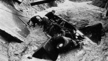
The 1938 showers were likely welcomed after a string of dry years, but the rainfall intensified the next day. The city received a break from the rain for a few hours on March 1, but a second system delivered steady downpours and the heaviest periods of rain on the morning of March 2.
The stage was set for catastrophe.
In LA County, some of the most severe flooding was in the San Fernando Valley as water rushed down from mountains to the north of Los Angeles and already saturated hillsides in search of a low point -- the Los Angeles River, then mostly un-channeled and wild, unlike today. At the time, Valley communities were more scattered than they are now, but there were areas of significant development along the river and anything in the water's path proved no match for the onslaught.
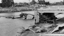
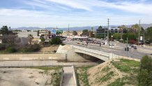
Part of Universal City's Lankershim Bridge crumbled in a collapse that added to what would become a staggering death toll. A restaurant and homes also were damaged near the bridge crossing and vast swaths of water isolated parts of the valley, cutting off communities, knocking out telephone services and washing out roads and bridges as the rapidly flowing river overran its banks on its march to the sea.
"The Los Angeles River the flood of March 1938 exceeded all previous floods for which records are available," according to a USGS report on the flood. "The highly developed areas along the Los Angeles River and its tributaries in the city of Los Angeles sustained the greatest damage."
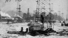
Here are some of the records related to the storms to provided some perspective on the disaster.
- Record Wettest Single Day: March 2, 5.88” (Downtown LA)
- February to March Rainfall: 17.75” with 11.06” falling in a five-day period . Considered a 1 in 50- to 100-year event.
- 1937-38 is part of the wettest five-year period on record (1937-1941 – 110.61”)
- 1937-38 is the 15th wettest season on record: 23.44”
Below, some of the rainfall totals.
- Los Angeles (USC): 11.06”
- Burbank Fire Department: 12.77”
- Pasadena: 14.81”
- Pomona Fairplex: 10.25”
- Santa Ana Fire Station: 7.73”
- Oxnard: 7.55”
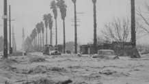
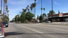
The river's rampage continued downstream in a confluence of destruction when overflow from creeks along the way added to the powerful current of water. Even areas that were not in the direct path of the river, such as Venice, sustained damage.
The death toll in Los Angeles County exceeded 100 people and the floods caused an estimated $70 million in damage. An estimated 5,600 homes were destroyed.
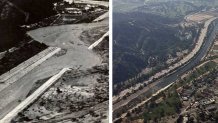
In Orange County, water spread out across low-lying areas from the Santa Ana River, which snakes down from the San Bernardino County Mountains and passes through San Bernardino and Riverside before crossing Orange County. Debris in the river collected under bridges, including one near downtown Riverside that gave way as the water muscled its way through the community. Farmland was flooded, canyon passes were cut off and rail lines were forced to shut down.
The devastation led to civil engineering decisions that shaped modern day Los Angeles. Here are some of the changes that followed the catastrophe.
- New flood control provisions.
- Channelization of the river after the flooding, some areas had already been completed.
- Sepulveda Dam and Hansen Dam are added to the LA River, and Santa Ana River gets the Prado Dam.
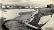
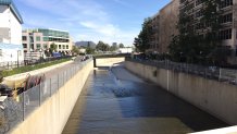
Part of the Los Angeles River had already been channelized with concrete slopes before the 1938 flood, but the natural disaster led to total channelization that would forever change the face of Los Angeles. For example, the section of river that battered the Lankershim Bridge now has vertical concrete walls and the river's confluence with the Tujunga Wash was moved upstream.
The river channel system, spurred by the federal Flood Control Act, took about 20 years to complete, resulting in a concrete barrier between humans and nature -- and a familiar backdrop for LA-based films.
There are only three locations where the river is not walled in -- the Sepulveda Flood Control Basin in the San Fernando Valley, a section near Griffith Park and an estuary in Long Beach where the river meets the Pacific Ocean.
The 1914 flood resulted in about $10 million in damage at a time when Los Angeles was still developing into the metropolis it is today. The destruction it wrought was followed by the formation of the county Flood Control District, which began early flood control projects like river channels and reservoirs.
The February-March storms marked an end to what had been a severe dry spell in Los Angeles, where no measurable rain had been reported from May to October 1937. But the threat of severe flooding was still top-of-mind in 1930s LA, where residents still had recollections of major floods in 1914 and 1934.
Even the Great Flood of 1862, the worst flood in the recorded histories of California, Oregon and Nevada, wasn't a too-distant historic event.

