What to Know
- Red flag warnings are in effect for the Malibu coast, Santa Monica Mountains Recreational Area, and the San Gabriel, San Fernando and Santa Clarita valleys.
- The warning will later extend to Los Angeles County beaches, the Palos Verdes Hills and the inland Los Angeles County coast stretching into downtown Los Angeles.
- Santa Ana winds will likely be strong enough to down trees, large branches and power lines.
- Caltrans plans to close Topanga Canyon Boulevard between Mulholland Drive and Pacific Coast Highway due to wildfire danger.
Strong winds swept across Southern California Tuesday with fire weather warnings in the forecast for widespread parts of Southern California.
Powerful offshore winds developed Tuesday morning when red flag warnings began for the Malibu coast, Santa Monica Mountains Recreational Area, and the San Gabriel, San Fernando and Santa Clarita valleys. The warning is expected to expire at 6 p.m. Thursday.
Get top local stories in Southern California delivered to you every morning. >Sign up for NBC LA's News Headlines newsletter.
Later Tuesday, the red flag warning signalling critical fire danger will extend to Los Angeles County beaches, the Palos Verdes Hills and the inland Los Angeles County coast stretching into downtown Los Angeles.
Any brush fires that start could quickly spread due to strong winds and dry conditions. Dry conditions persist throughout Southern California this wet season, which started in October. Downtown LA has received 0.16 inches of rainfall so far this season, well below the average of 4.41 inches for this time of year.
Send us your windstorm photos
"We're at a big deficit and, unfortunately, no rain on the horizon," said NBCLA forecaster Belen De Leon.
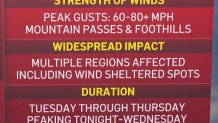
The winds will likely be strong enough to down trees, large branches and power lines. Santa Ana winds could gust at speeds of 60 mph to 80 mph with some peak gusts reaching 90 mph on mountaintops.
"This is a widespread impact event, affecting multiple regions, including sheltered areas that don't usually see winds," said De Leon "Places like Burbank, Pasadena, Claremont, Simi Valley. You may even see winds all the way out to the South Bay."

Parts of inland Orange County, San Bernardino and Riverside counties and coastal Ventura County also will be under red flag warnings and high wind watches.
The strongest gusts are expected Tuesday evening into Wednesday.
In a post on X, the National Weather Service described the windstorm as "life-threatening."
HEADS UP!!! A LIFE-THREATENING, DESTRUCTIVE, Widespread Windstorm is expected Tue afternoon-Weds morning across much of Ventura/LA Co. Areas not typically windy will be impacted. See graphic for areas of greatest concern. Stay indoors, away from windows, expect poweroutages. #LA pic.twitter.com/yl83LxeMEc
— NWS Los Angeles (@NWSLosAngeles) January 6, 2025
Caltrans plans to close Topanga Canyon Boulevard between Mulholland Drive and Pacific Coast Highway from 10 a.m. Tuesday through 6 p.m. Friday due to increased fire risk. Only residents and local business traffic will be permitted into the canyon during the closure.
Southern California Edison customers in some areas could have their power turned off under the utility's Public Safety Power Shutoffs program, standard procedure when warranted due to fire weather conditions. Power lines that could be damaged and sparked a fire are de-energized.
🚧🚧 Topanga Canyon Blvd (SR-27) will be CLOSED from 10 AM Tue. to 6 PM Fri., Jan. 7-10, in #Topanga due to Red Flag Warning fire danger. Only residents & local business traffic allowed in the canyon. #Malibu #SantaMonica #WoodlandHills #TCB #Mulholland #PCH #CAwx pic.twitter.com/9TJNrOxbPU
— Caltrans District 7 (@CaltransDist7) January 6, 2025
According to SCE's website, more than 70,000 customers in Los Angeles County and more than 9,400 in Orange County are under consideration for power shutoffs.
Temperatures will drop by 5 to 10 degrees Tuesday due to cold air accompanying the system.
What to know about Santa Ana winds
Wind moves from high pressure to low pressure. When you add Southern California's rugged topography of mountains, canyons and passes, that wind can now pick up speed as it's channeled through those areas.
Wind strength can also be enhanced by cold air to our east. This cold air charges the atmosphere.
As the air gets to the top of the mountain it races down, it acts like a bike with no brakes and gaining speed. The canyons and passes act as a toll road. The wind piles up and once it squeezes through the canyon it races out in a powerful blast of wind.
And wind that is moving down a mountain dries as it sinks. It’s more physics than meteorology, but this drying lowers the humidity into the single digits. The combination of dry fuels, low humidity, and strong gusty winds create a critical fire weather threat. If a fire starts it can spread rapidly and behave erratically due to wind gusts.
Santa Ana winds occur in the fall lasting through the winter.


