
What to Know
- Tioga Road reopens at 8 a.m. on July 22
- The road is the main route into Yosemite National Park when traveling from the Eastern Sierra
- The high-elevation road is closed for several months each year due to snow accumulation
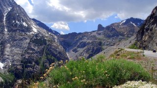
PAUSES, MOMENTS, STILLNESS: While Yosemite National Park is rife with energetic activities that encourage movement, from hiking to climbing, there are ample opportunities around the epic landscape to take it easy, slow down, and fold in some reflection. Visitors preparing to enter the national park from its Eastern Sierra entrance, beginning on July 22 at 8 a.m., may take some of these take-it-slower ideas to heart as they make their unhurried way along the world-famous Tioga Road. For while the high-elevation pass will finally reopen after months of snow removal on July's penultimate Saturday, travelers should expect some waiting along the way. "Tioga Road has some damage, so watch for one-lane sections, with delays up to 15 minutes just east of Olmsted Point," shared the National Park Service. Still, this is a huge deal, especially for those Yosemite fans based in Bishop, Mammoth Lakes, June Lake, and points around Mono County and beyond.
DRAMATIC WINTER WEATHER... resulted in several damaged roads throughout the region, as well as later-than-normal opening dates. And July 22 is indeed a "later date" for Tioga Road; May and June reopenings are far more typical (you can view several decades of opening and closing dates on this page). Want to cycle into the park? You've got an earlier date to enjoy the scenic thoroughfare: July 21. The National Park Service has several tips for driving (and pedaling) the road, including what services are available and what campgrounds remain closed. And very importantly? "It's still snowy up there!," shares NPS. "Meadows and some trails are flooded. Snow is persisting in some shady areas as low as 8,000 feet, with extensive, deep snow coverage by 9,000 feet. Stay on trails to protect growing plants and plan for wet feet. Marked trails may be hard or impossible to follow; hikers should have GPS, as well as map and compass (and know how to use them)."
BE IN THE KNOW: More essential information for Tioga road-trippers can be found on this site.
Get top local stories in Southern California delivered to you every morning. Sign up for NBC LA's News Headlines newsletter.